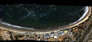
Tar Balls from California Oil Spill Litter Beach in NASA Photo

This story was updated on 9 July at 2:38 p.m. ET.
Spotting dark, gooey and flammable tar on the beach — remnants from an oil spill in Southern California in May — just got a lot easier, thanks to NASA.
The agency recently captured a light-sensitive image of tar-seeped sand and water in Santa Barbara to help officials study and respond to the spill.
"Mapping tar on beaches using high-resolution imaging spectroscopy techniques that can identify tar of this type has never been done before, and is a natural extension of oil-on-water remote sensing," Ira Leifer, principle investigator of the oil spill and an environmental consultant, said in a statement.
The oil spill, also known as the Refugio Incident, occurred on May 19 when a pipeline operated by Plains All American Pipeline burst. Roughly 21,000 gallons of oil leaked into the Pacific Ocean, in the north Santa Barbara Channel, located about 100 miles (161 kilometers) northwest of Los Angeles. 101,000 gallons of crude oil also spilled onto Refugio State Beach, just north of Santa Barbara, according to NASA. [SOS! 10 Major Oil Disasters at Sea]
Plains All American Pipeline doesn’t have a stellar safety record, with 175 safety and maintenance infractions since 2006, reported the Los Angeles Times. Since 2004, mechanical failures on Plains' pipelines have released around 2 million gallons of hazardous liquid in Canada and the United States, according to the Times.
Leifer collected tar balls — lumps of solidified crude oil — on the affected beach in Santa Barbara and analyzed them in a laboratory. Leifer identified the unique way that the tar balls absorb and reflect different wavelengths of light, which NASA then used to spot other tar balls from the air.
Sign up for the Live Science daily newsletter now
Get the world’s most fascinating discoveries delivered straight to your inbox.
NASA deployed a De Havilland Twin Otter aircraft with an advanced camera-type instrument that was developed at the Jet Propulsion Laboratory in Pasadena, California. The instrument, called an Airborne Visible Infrared Imaging Spectrometer, Next Generation (or AVIRIS-NG), measures light reflected from Earth's surface and decodes it into surface properties.
Once the AVIRIS-NG knew to look for a specific light-absorption and -reflection signature radiating off the tar balls, it identified and mapped their locations over a 220-foot (67 meters) span of the beach.
AVIRIS-NG has previously been used to map ecosystems, minerals, land use and trace gases, according to NASA. The first-generation AVIRIS was used to survey the Gulf of Mexico after the 2010 Deepwater Horizon oil spill.
The Deepwater Horizon spill had far-reaching effects on marine biodiversity, affecting coral reefs and dolphins, among many other species. But accounting for all the missing oil can be problematic, so the extent of impacts can remain unknown for many years.
NASA's images are part of the agency's Disasters Program, and will help local, state and federal officials assess the impact to the beach and guide its restoration. "NASA is keenly interested in fostering development of new operational remote-sensing technologies that improve disaster response for application by federal responders," said David Green, the NASA disasters program manager in Washington, D.C.
Editor's Note: The story was updated to reflect the corrected estimate of oil that was spilled on Refugio Beach. NASA now says 101,000 gallons of crude oil spilled, not 105,000 barrels.
Elizabeth Goldbaum is on Twitter. Follow Live Science @livescience, Facebook & Google+. Original article on Live Science

