2014 Will Be Earth's Hottest Year on Record, Despite US Cold

Wintry storms could bury Buffalo, New York, under heaps of snow until Christmas, but 2014 will still be the hottest year on Earth since 1880, climate scientists said today (Nov. 20).
"It's becoming pretty clear that 2014 will end up the warmest year on record," said Deke Arndt, chief of the climate monitoring branch at the National Climate Data Center. "The remaining question is, by how much."
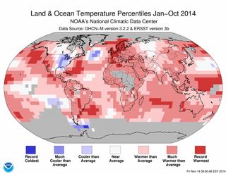
The eastern United States was one of Earth's cold zones this year, with temperatures running 2.7 degrees Fahrenheit (1.5 degrees Celsius) below average, scientists from the National Oceanic and Atmospheric Administration (NOAA) said today during the agency's monthly climate briefing. But the bitter cold couldn't offset record-breaking heat waves in California, Europe and Australia this year, nor the incredible warmth in the world's oceans. [In Images: Extreme Weather Around the World]
"Notably, every major ocean basin and every continent all had some pieces — and some had significant pieces of their area — that were the warmest on record [during 2014]," Arndt said. "It's virtually certain that California will have its warmest year on record, even if California has record cold in December."
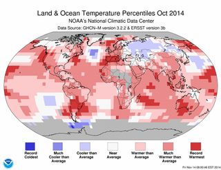
October was the sixth straight month of chart-busting heat in the oceans, according to NOAA. Last month was also the hottest October on record for land temperatures.

Combining land and sea temperatures, the average worldwide temperature of 58.43 F (14.74 C) for October 2014 topped the previous high set in October 2003 by 0.02 F (0.01 C). November 2013 through November 2014 is now the warmest 12-month stretch on record for any 12-month period recorded since 1880, NOAA said.
With less than two months left in 2014, the planet is on track to beat the warmest years in the historical record. So far this year, worldwide temperatures are averaging 58.62 F (14.78 C). The entire planet would have to go through a cold snap for 2014 to miss finishing in the top 10. (And it may feel that way for people in eastern North America and eastern Russia, where heavy snows arrived early this year.)
Sign up for the Live Science daily newsletter now
Get the world’s most fascinating discoveries delivered straight to your inbox.
Two giant pools of warmer-than-average water in the Pacific Ocean helped boost global temperatures in 2014, NOAA scientists said. One pool is sloshing around the eastern Pacific along the equator, and is related to the El Niño climate pattern that is struggling to develop. The other pool is a large mass of warm water stretching from Alaska to California. These warm, West Coast waters suggest that a decades-long natural climate pattern called the Pacific Decadal Oscillation (PDC) has flipped into its positive phase, said NOAA forecaster David Unger. The PDO influences weather in North America by shifting the jet stream and changing where rain and snow fall, similar to El Niño's worldwide effects.
Sea surface temperatures in the northern Pacific Ocean haven't been this warm in 10 years, Unger said. "Whether it will stay this way, only time will tell," he said. The PDO has generally been in a negative, or cold phase, since 1998, scientists think.
Follow Becky Oskin @beckyoskin. Follow Live Science @livescience, Facebook & Google+. Originally published on Live Science.

Most Popular

